Fishing Essentials Every Beginner Needs

Hobart In Lake County Indiana is Known for it’s Biodiversity and Wetland Ecosystems

     Northwest Indiana—especially Lake County along the southern shore of watershed basin of Lake Michigan — contains one of the most ecologically diverse regions in the whole county. This diversity comes from the area’s unique glacial history, the mixing of dune, wetland, and prairie ecosystems, and the influence of Lake Michigan’s moderating climate.
    A fairly large variety of endangered, threatened, and rare (ETR) (Ecological Threat Register) species and high quality natural areas have been documented within the Deep River-Portage Burn Waterway watershed. The largest contiguous wetland tract is located on Deep River downstream of Lake George. (here) The Indiana Natural Heritage Data Center has recorded nearly 400 observations of ETR species including plant, reptile, amphibian, bird, mammal, crayfish, mollusk and crayfish species and 32 high quality natural communities including forest, savannah, prairie, and wetland habitats within its boundary.
     The watershed’s diversity can be attributed to its location in the landscape. The Deep River-Portage Burns Waterway watershed falls in an area known as the Northwestern Morainal Natural Region. Several major vegetation types including the eastern deciduous forest, the tall grass prairie, and northern forest and wetland merge in this natural area. No other natural region compares in species diversity on an acre by acre basis because of this (Homoya et al, 1985).
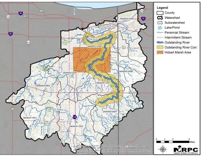
nirpc deep river hobart marsh watershed development best management practices development
Heres’s what is says on the 2017 NIRPC FILES
    High concentration areas still remain unprotected. Notable areas include along the Little Calumet River and Deep River downstream (FLOWING NORTH TO LAKE MICHIGAN) of Lake George. Conservation of these land areas is not only important to protect critical habitat for ETR (Ecological Threat Register) species, but also in protecting the variety of services (ex. flood attenuation) they provide to society and the watershed as a whole. Additional high quality natural communities and ETR species may still be present in the watershed that have yet to be documented. A list of the ETR species and high quality natural communities that have been documented in the watershed is included in the appendices. Information on which community types the ETR species and high quality natural communities occur is also provided (Source: Derek Nimetz, DNR Division of Nature Preserves). The The largest contiguous wetland tract is located on Deep River downstream of Lake George. (“downstream” is actually north to Lake Michigan)
indiana natural heritage data center hobart indiana

     The Indiana Natural Heritage Data Center (INHDC) represents a comprehensive attempt to determine the state’s most significant natural areas through an extensive statewide inventory. However, the inventory is a continuous process. Over the past 10 years, 57 element occurrences were documented in the watershed including 54 ETR species and 3 high quality natural communities. (Please note, to find this info click here and you’ll find the link at the bottom)
     In 2018 the City of Hobart and the Northwestern Indiana Regional Planning Committee (NIRPC) engaged The Lakota Group along with Duncan Associates to create a set of zoning standards to guide the use and design of sites within the city of Hobart’s conservation areas. This process resulted in the creation of “conservation” zoning districts to be applied to existing and future managed conservation wetlands, river basins, and lands surrounding Lake George.

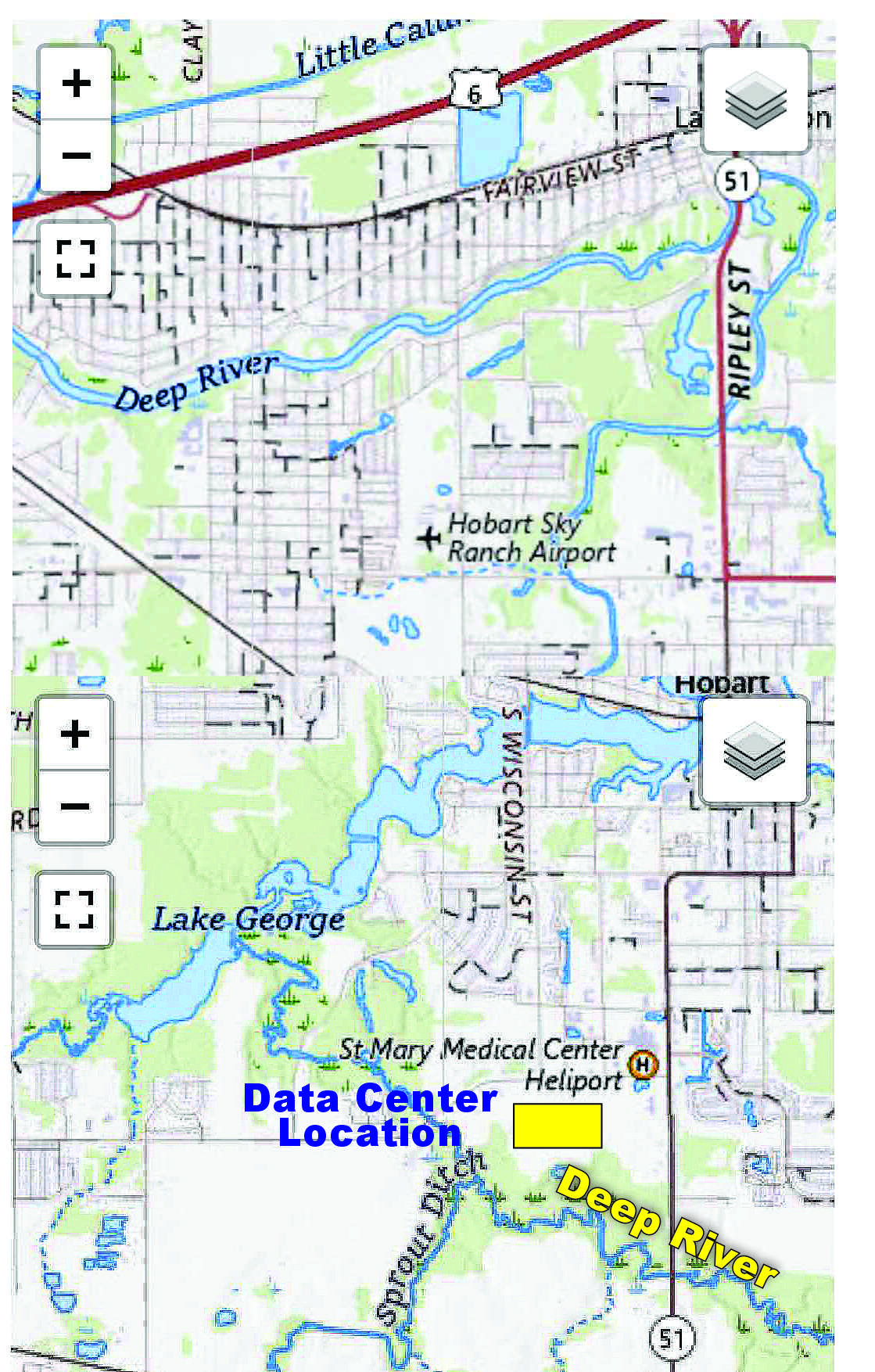
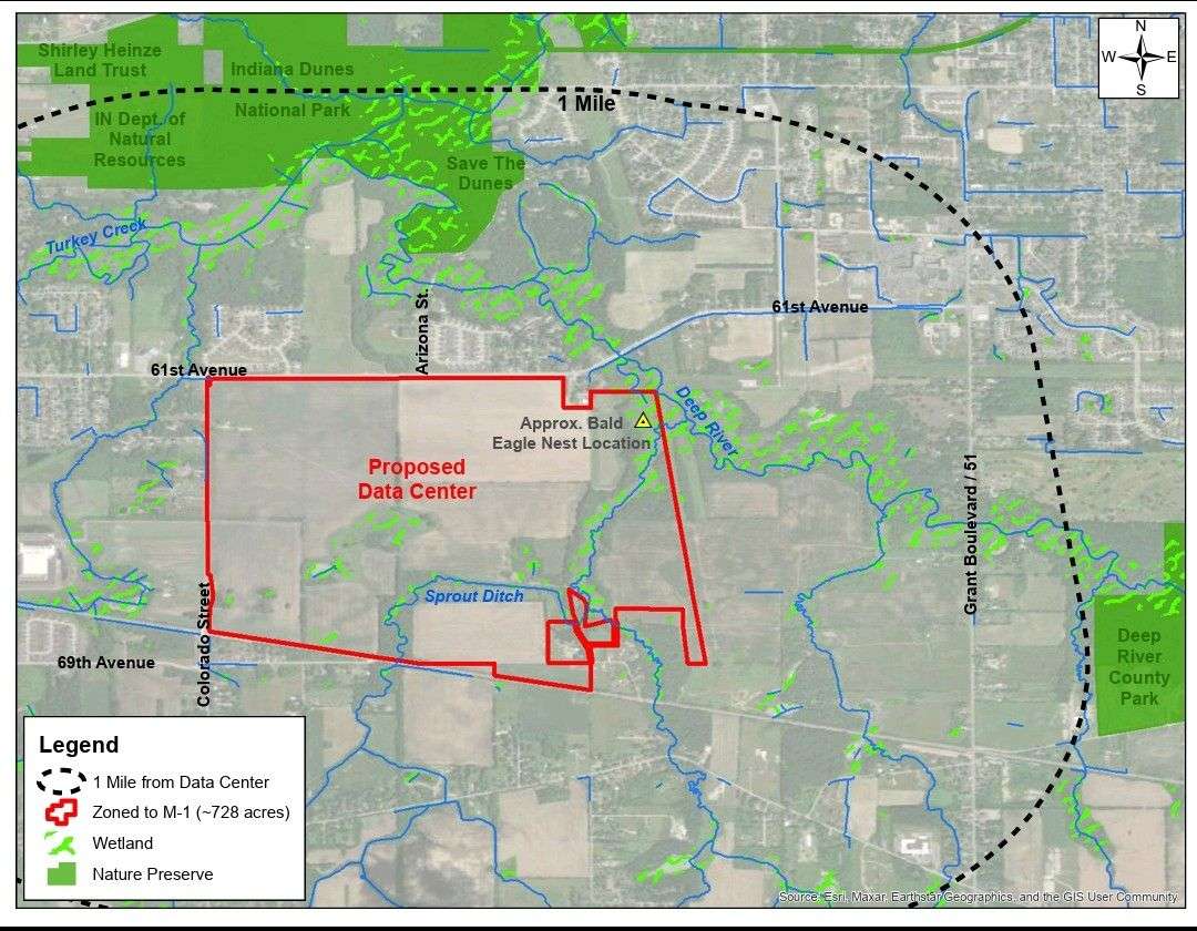
data center in Hobart Indiana Amazon close to Deep River Wetlands map scaled
     The new district identifies permitted uses and activities and specifies the need for and rules governing natural resource management plans. The sub-area plan identifies areas where conservation is needed to protect the Lake George watershed and preserve local habitats, and determines parcels where conservation and development partnerships could occur. Illustrative renderings for priority sites within the sub-area show areas where low-impact development best practices were identified. Wetlands are vital for water quality, acting as natural filters and buffers. They are also important for nesting birds and supporting threatened and endangered species, notes IN.gov

LOCAL Forested Wetlands, Scrub-Shrub Wetlands, Emergent Wetlands, Woody Vegetation Herbaceous Vegetation
WITHIN ONE HALF MILE INCLUDE:

Dorothy Buell Oak Savannah Preserve on Lake George,
DNR Nature Preserve and the
Indiana Dunes Nature Preserve, AKA Hobart Prairie Grove And Hobart Woodland Trail
(It is noted for high biodiversity, containing over 343 native plant species and unique clay/silt soil)
Gordon & Faith Greiner Nature Preserve, Operated by Shirley Heinze
a part of Shirley Heinze Land Trust
Deep River Wetlands AND the 
Hobart Marsh Area, ( encompasses nearly 750 acres of permanently protected marsh ecosystem adjacent to Lake George with bottomland forests, restored prairie-savannas and threatened bird species )
Deep River Watershed (A half-mile buffer was established around the Deep River outstanding river reach using GIS to identify the Deep
River Outstanding River Corridor. This buffer width effectively captured a high percentage of natural land cover
areas, core forests, documented high quality natural communities and ETR species, and managed lands along Deep
River.)
and
USGS National Water Dashboard 3 23 26 discharge recording
Get Deep River’s (USGS) United States Geological Survey info here

Lake George  (Shown Above) USCS National Water Dashboard Recording on March 23/ 2026
You can find the USGS Interactive Map here
USGS FACEBOOK PAGE

Just Because You Don’t See Water, Doesn’t Mean it’s Not A wetland:

     Certain types of wetlands have natural wet-dry cycles such as ephemeral wetlands and fens and therefore may appear dry at the surface. Ephemeral wetlands are isolated ecosystems that temporarily hold water in spring and early summer, while fens are ground water fed and receive their water and nutrients from below the surface.
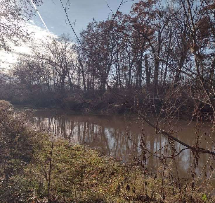
deep river wetlands in hobart indiana next to the data center eagles e1763739566798

Species Known or Likely in the Deep River / Hobart Marsh Wetland Area

     This list draws from the Deep River / Turkey Creek Watershed Management Plan, the Hobart Marsh Plan, and state conservation data.

🐢 Reptiles

     Blanding’s turtle (Emydoidea blandingii) — This is a state – endangered species in Indiana. Also Photographed by two Local Hobart Residents And Documented in core wetland/river corridor. 

     Eastern massasauga rattlesnake (Sistrurus catenatus) — Listed in Lake County’s rare species list. Indiana.gov

     Smooth green snake (Opheodrys vernalis) — Also appears on the Lake County rare species list. Indiana.gov

     Woodland box turtle (Terrapene carolina carolina) — On Lake County rare species list. Indiana.gov
Also Photographed by two Local Hobart Residents


🌿 Plants (Flora)

From watershed and marsh planning documents, plus Lake County rare species list:

     Small purple-fringed orchid (Platanthera psycodes) — Named in the watershed management plan as present in the area. Chicago State University+1

     Highbush cranberry (Viburnum americanum) — Possibly present in wet-mesic forest areas. Chicago State University

     Downy gentian (Gentiana puberulenta) — Listed in Lake County endangered / rare species. Indiana.gov

     Yellow gentian (Gentiana alba) — Also on Lake County rare plant list. Indiana.gov

     Heart-leaved plantain (Plantago cordata) — On Lake County list. Indiana.gov

     Carey’s smartweed (Persicaria careyi) — Rare plant in Lake County. Indiana.gov

     Sparganium androcladum (Branching bur-reed) — Also on the Lake County list. Indiana.gov


photo of sandhill cranes taken in Deep River Hobart Indiana south side by the data center location
🐦 Birds

     The watershed plan (Deep River / Turkey Creek) mentions several state – endangered (at the time of the report) bird species that have been observed or are of concern in or near the watershed / marsh:

     King Rail (Rallus elegans) — Reported in watershed plan. Photographed by Local Hobart Resident 

     Marsh Wren (Cistothorus palustris) — Also noted in the plan.  Recorded by Local Hobart Resident

     Black-crowned Night-Heron (Nycticorax nycticorax) — Observed historically.Photographed by Local Hobart Resident 

     Loggerhead Shrike — Also mentioned in older records per the watershed plan.Photographed by Local Hobart Resident 

     Trumpeter Swan – Photographed by Local Hobart Resident 

    Here’s a list of MORE endangered birds in Indiana:
American Bittern, Black Tern, Barn Owl,  Black-crowned Night-Heron,  Black Rail FT,  Cerulean Warbler, Common Gallinule,  Golden-winged Warbler,  Henslow’s Sparrow, Kirtland’s Warbler, King Rail,  Loggerhead Shrike, Least Tern FE, Least Bittern,  Marsh Wren, Northern Harrier,  Piping Plover FE,  Ruffed Grouse,  Rufa Red Knot FT, Short-eared Owl,  Sedge Wren, Trumpeter Swan, Upland Sandpiper, Virginia Rail, Whooping Crane FE,  Yellow-headed Blackbird, Yellow-crowned Night-Heron,

🐦 Bald Eagles

bald eagle nest taken by jennifer williams who lives next to the hobart data center in hobart indiana e1764715087584

— There have been several sighting of Bald Eagle nests very close to the proposed Data Center Location at 61st Ave and Colorado Street. According to the Indiana DNR Website “Although bald eagles are no longer listed, they are protected by other state and federal laws, including the Bald and Golden Eagle Protection Act. If you see bald eagles in Indiana, observe the birds, their nests, and roosts from a distance of 330 feet, which is roughly the length of a football field. Photography enthusiasts should take photos of eagles with a telephoto lens. Foster a climate of respect for wildlife by sharing these guidelines with your friends.”
     You can report a bald eagle nest in Indiana by emailing the Indiana Department of Natural Resources (DNR) at dfw@dnr.IN.gov or the volunteer database manager, John Pohl, at baeanests@yahoo.com. Also you can email agillet@dnr.in.gov as well. Provide the specific location (GPS coordinates, drop pin, or nearest road intersection) and a photo if possible. When observing, maintain a distance of at least 330 feet to avoid disturbing the birds.

     There is a DO NOT DISTURB Law,

  • Do not disturb the nest: The Bald and Golden Eagle Protection Act protects eagle nests year-round. Do not remove or relocate a nest without a specific permit.  For information on the protection of protected species, contact:

    Allisyn Gillet – AGillet@dnr.IN.gov Ornithologist
    Indiana Department of Natural Resources
    Division of Fish & Wildlife
    5596 E State Rd. 46, Bloomington, IN 47401
    812-334-1137 ext. 3400 –

 Find out more info about disturbing nests from the US Fish & Wildlife Website here.


🐛 Insects

     Bunchgrass skipper (Problema byssus) — The watershed plan lists this as a state-rare insect species in the upland prairie portion of the watershed. Photographed by Hobart Resident Vernon Shaw.

According to Hobart Nature District documentation, there are over 40 state endangered, threatened, or rare insect species in the Hobart Marsh / Deep River area. Wikipedia 
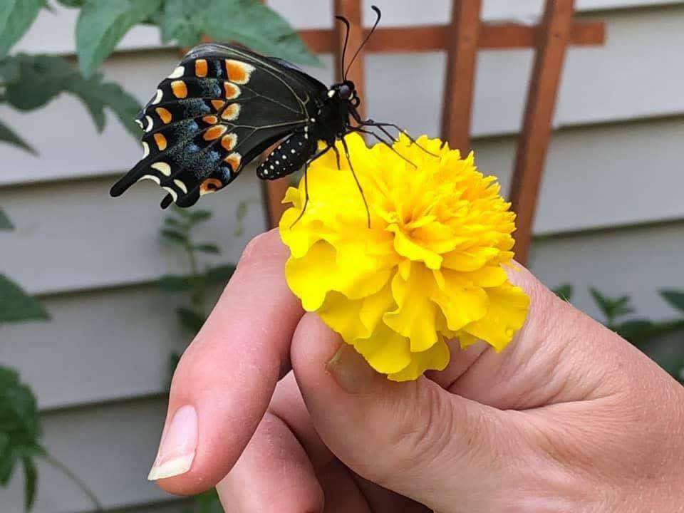
swallow tail butterfly photo taken in Hobart indiana at the data center location
Swallow Tail Butterfly is endangered insect,  Photo by Jennifer Williams, Hobart Resident, from her backyard.


Eastern bee balm Monarda bradburiana taken by Vernon Shaw hobart indiana resident e1764004228935Eastern bee-balm (Monarda bradburiana) is an endangered insect, photo taken by Vernon Shaw Hobart indiana resident.
(Posted on Facebook, November 21st, 2025)


🐟 Aquatic Invertebrates / Macroinvertebrates

     The Deep River–Burns Waterway Watershed report mentions macroinvertebrates (invertebrates without backbones) as a large component of the aquatic biotic community in the river / wetland system. Indiana.gov

     These macroinvertebrates are used as indicators of water quality in the watershed. Indiana.gov


Why Conservation Matters

     Many of the species listed are rare, threatened, or endangered at the state level (Lake County / Indiana). Indiana.gov
     Because of the conservation importance, the Hobart Marsh Plan explicitly identifies parts of the wetlands and riparian zones (like along Deep River) as priority areas to protect. cityofhobart.org

Habitat Types

    The area includes high-quality natural communities such as wet-mesic forest, upland mesic forest, and wetlands. Chicago State University

     These habitats support not only wetland species, but species that use both upland and wetland zones, which increases biodiversity.

Ongoing Risk & Monitoring

     Because of development and water-quality issues, the Deep River / Turkey Creek Watershed Management Plan was developed to guide conservation and restoration. Chicago State University+1

     The presence of macroinvertebrates and sensitive species is used to track ecological health. Deep River Burns Waterway 2017 (Note this is a 377 page pdf)


Summary

The Deep River wetland / Hobart Marsh area supports a diverse set of species, including rare plants, birds, and reptiles, particularly those associated with high-quality wetland and forested wetland habitat.

State-rare and endangered species like the Blanding’s turtle, certain orchids, and rare rails and wrens highlight the conservation significance of this area.

There is clear documentation of both biological richness and ongoing ecological concern, which has driven local and regional conservation planning.

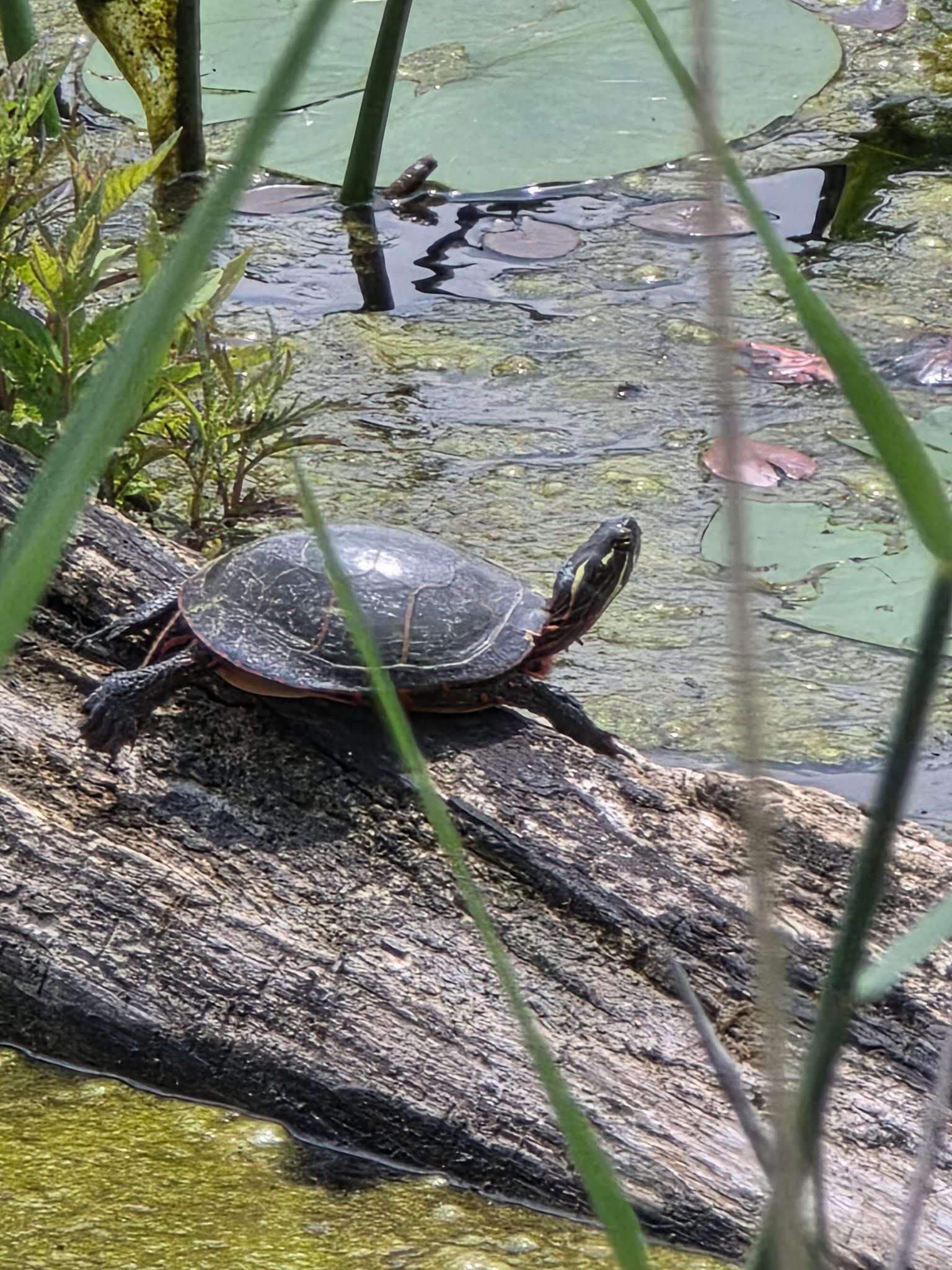
blanding turtle photo take by a Hobart indiana resident that lives by the hobart data center locationanother blanding turtle photo taken at the hobart data center location


Here are two photos of the Endangered Species the blanding turtle taken in 2025 by residents that live near the Hobart Data Center Location

Deep River Wetland Soil Composition


Deep River-Portage Burns Waterway Watershed January 18, 2017 (page 36)
    Table 6 (LINK ABOVE) provides a summary of hydrologic soil group data for each sub watershed and the watershed as a whole while Figure 11 shows their locations. Deep River Wetlands are Classified as Group C/D where the soils are the most common hydrologic soil group accounting for 43% of the watershed area. In drained areas these soils are classified as Group C and have a slow infiltration rate when thoroughly wet.   The second most common hydrologic soil group within the watershed is Group C. Areas either classified as Group C, C/D or D tend to strongly correspond with soil surface textures that are silty. In general, silty soils also tend to be more erodible than sandy or clayey soils.   Soil surface texture in this area is typically sandy to loamy and less prone to erosion. Given the prevalence of Group C and C/D soils throughout the watershed, there is generally a moderate to high potential of runoff being generated during precipitation events. Between 80-90% of the soils in the Headwaters Main Beaver Dam Ditch, Main Beaver Dam Ditch – Deep River and City of Merrillville -Turkey Creek sub-water – sheds have low or very low infiltration rates, causing high potential for run-off.

data center in Hobart Indiana Amazon close to Deep River Wetlands map 1 scaled

Conclusion

     Wetland conservation is essential for maintaining high water quality because wetlands act as natural filters, buffers, and stabilizers within a watershed. As water moves through a wetland, plants, soils, and microbes trap sediments, absorb excess nutrients like nitrogen and phosphorus, and break down pollutants such as chemicals, heavy metals, and pathogens. Wetlands also reduce flooding by storing stormwater and releasing it slowly, which decreases erosion and prevents large amounts of sediment from washing into rivers and lakes.
     Their dense vegetation stabilizes streambanks and shorelines, keeping water clearer and healthier for aquatic life. In addition, many wetlands help recharge groundwater, naturally filtering it as it percolates into underground aquifers that supply drinking water. By performing these roles, wetlands provide a free, highly effective form of water treatment that would be extremely costly to replace with human-built systems. In short, conserving wetlands directly protects water quality and supports the health of entire ecosystems and communities.

References:

2025 EPA Urban Waters Federal Partnership Work Plan: Restoring Duck Creek Tributary, Hobart Marsh Properties Managed by the Indiana DNR, Division of Nature Preserves, and Hobart Marsh Conservation Area known as NIPSCO Row.

deep river water shed is 29 miles long alliance for the great lakes

2017 –  NIRPC –  377 Pages. Deep River Portage Burns Waterway Final
Deep River-Portage Burns Waterway watershed (Figure 1). It is the largest of six watersheds located within the Little Calumet-Galien sub-basin, draining approximately 180 square miles of north central Lake and Porter Counties to Lake Michigan. Some the major streams located within the watershed include Deep River, Main Beaver Dam Ditch, Turkey Creek, and the Little Calumet River’s West Branch. This watershed management plan is the result of numerous communities and organizations coming together to establish a framework to restore the nearly 125 miles of impaired stream within its boundaries.

2024 – Save the Dunes Conservation Action Plan – 50 pages Hobart Marsh And Deep River Conservation Area was designated a Priority 1 Conservation Area by Save the Dunes Executive Summary of 2023 

2016 – IDEM – 373 Pages – Deep River Watershed Plan, Click here
The Deep River/Portage Burns watershed, identified as the hydrologic unit code (HUC) watershed 0404000105, covers a drainage area of approximately 180 square miles in northwestern Indiana, of which 104 square miles are located in Lake County, and 20 square miles are located in Porter County. There are approximately 125 miles of impaired streams within the watershed boundary.

2024 EPA – “Great Lakes Restoration Restoration Initiative” – (Grand Calumet River) 20 pages Click here

2020 DNR – Pages 47 and 78 – 81, Northwest Moraine Forest Legacy Areas 
CFAA funds are provided to states through the State and Private Forestry (S&PF) organization of the USDA Forest Service. Currently, Indiana receives these funds annually to assist private forest landowners, promote healthy forest practices, assist communities with their urban forests and protect communities from wildfire. A large portion of the CFAA funding received by the Indiana Division of Forestry is passed to local organizations by way of grants that provide matching funds and additional implementation resources.


2018 the City of Hobart
 and the Northwestern Indiana Regional Planning Committee (NIRPC) engaged The Lakota Group and the Northwestern Indiana Regional Planning Committee (NIRPC) engaged The Lakota Group The PLAN City of Hobart and the Northwestern Indiana Regional Planning Committee (NIRPC) have initiated a planning process to create a set of zoning standards to guide the use and design of sites within local conservation areas. The goal of this project is not to prohibit development, but to define the opportunities where development can take place in a manner that respects and enhances
conservation areas – both by reducing adverse impacts of adjacent land uses and by improving local access to wildlife where appropriate. The City of Hobart has engaged The Lakota Group along with Duncan Associates to complete this Conservation Zoning and Sub Area Plan.

2002 – Chicago State University, 180 pages, Deep River – Turkey Creek  Watershed Management Plan  In the late 1980’s, the City of Hobart, in partnership with a local private economic development organization, began a program to improve the community’s quality of life and retain and expand business within the City that resulted in a multi-phased lakefront development and downtown revitalization plan. Degrading water quality, recreational uses, and aesthetic issues began to pose a threat to the community’s investments in lakefront and downtown revitalization efforts as a growing sedimentation problem in Lake George was becoming obvious. Accumulating sediments were precluding the use of the lake as a recreational resource for boating, degrading habitat for biological communities, and reducing recreational fishing opportunities in the lake. In addition, overgrowing plant life began to cause an aesthetic nuisance to lake residents and recreational enthusiasts.

Hobart Marsh Plan
(2016) (Recently added)  Created by the IDEM, and Lake Michigan Coastal Program.
     The Deep River/Portage Burns watershed, identified as the hydrologic unit code (HUC) watershed 0404000105, covers a drainage area of approximately 180 square miles in northwestern Indiana, of which 104 square miles are located in Lake County, and 20 square miles are located in Porter County. There are approximately 125 miles of impaired streams within the Deep River watershed boundaries.
In 2011, the Northwestern Indiana Regional Planning Commission (NIRPC) identified the Deep River-Portage Burns Waterway Watershed as a priority in the Northwest Indiana Watershed Management Framework. The decision to include the watershed as a priority was based on persisting water quality issues, but more importantly, because stakeholders continued to express interest in reinvigorating these past efforts. With substantial changes in land use being evident, there was enough support to update the previous watershed plans into a single comprehensive plan.
lake george hobart indiana amazon data center deep river sprout ditch
     In 2017, the Northwestern Indiana Regional Planning Commission (NIRPC) identified the Deep River Portage Burns Waterway Final as a priority in the Northwest Indiana Watershed Management Framework. The decision to include the watershed as a priority was based on persisting water quality issues, but more importantly, because stakeholders continued to express interest in reinvigorating these past efforts. With substantial changes in land use being evident, there was enough support to update the previous watershed plans into a single comprehensive plan.

Chicago State University (2009) Stewardship in the Calumet Region:
Stewardship in the Calumet Region – Again in partnership with SHLT, IDNR Nature Preserves, and possibly LCP and the Indiana Dunes National Lakeshore, Save the Dunes is part of a proposal for contract work and management at Hobart Marsh, a large complex in Hobart Prairie Grove (the  majority of which is owned by the Indiana Dunes National Lakeshore). Hobart Prairie Grove is a very large complex of wetlands, and the goal is to convert old agricultural fields on the site into restored prairie. Should funding be secured, the project would begin in 2010. The site is in need of prescription fire and cattail control, among other restoration work. Another Great Lakes proposal which Save the Dunes is a part of is one that is an Indiana Department of Environmental Management proposal. This proposal involves restoration at all the dune and swale projects managed by SHLT, STD, IDNR Nature Preserves, TNC, and LCP.

(2025) UNIVERSITY OF MICHIGAN: Gerald Ford School of Public Policy:
What Happens When Data Centers Come To Town :
Current technologies force a tradeoff between energy and water efficiency, limiting sustainable solutions.  Data Centers Do Not Bring in High Paying Jobs; Data Center Tax Breaks Only Benefit Corporations; Reduces Tax Revenue for School Districts; Higher Energy Rates for Consumers; Higher Resource Consumption; And Much More.

In a CWP Reports,  Center for Watershed Protection‘s  There Are 100 Scientific Studies On How Urban Development Leads To Habitat Loss, Altered Water Levels And Water‑Flow systems, Changing Sediment buildup And Nutrient Cycles, And Thereby Degrading Wetland Functions. (Center for Watershed Protection)
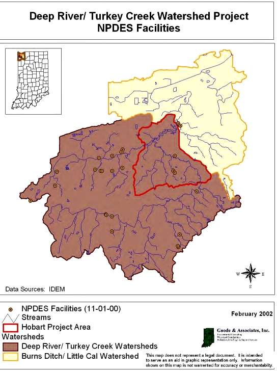
deep river turkey creek watershed map in hobart indiana by the chicago state universityMap of the Little Calumet River Watershed Basin,
the Turkey Creek watershed and the
Deep River Watershed Basin
new data center map
To File An Air Pollution Complaint to the IDEM
online Click here 

To File and Environmental Emergency complaint Call:
 888-233-7745 or Click here
To File a Wetland Complaint Call: 800-451-6027
Or Click here

To File a Complaint regarding Rivers, Streams, or Lakes, Call 800-451-6017 opt 3 of Submit an Online Complaint here.

CLICK HERE TO SUBMIT AN ENDANGERED SPECIES COMPLAINT TO THE State of Indiana
You can also request an in-person review

Please note: Requests for this information are assessed a fee based on the time needed to complete the request. This charge is $42 per one-half hour, one half-hour minimum. Most requests take one-half hour or less to complete. An invoice for the amount due will be included with the completed request response. This fee is waived for nonprofit organizations, other governmental agencies, and educational research projects.

Please allow two weeks for return of the requested information.

For questions or support please contact Taylor Davis Astle at tdavis@dnr.IN.gov

MORE RELATED ARTICLES . . . 


Chase Street Complex Wetland Restoration effects little calumet river hobart indiana gary indiana hammond indiana deep river scaled

West Little Calumet River Wetland Restoration Project in Gary, Hammond and Hobart Indiana

     The Wetlands Initiative (TWI) was awarded a $794,000 grant from the National Fish and Wildlife Foundation’s (NFWF) National Coastal Resilience Fund (NCRF) to complete this “Community-centered Final Design” phase. This project is being collaboratively facilitated by the Little Calumet River Conservation Collaborative.      The West Branch of the Little Calumet River corridor covers…

Continue Reading →


EMF Concerns at Data Centers killing wildlife 2

EMF Concerns at Data Centers (And Mechanical Waves)

     Data Centers pose greater net risks by creating “EMF Vibrations” that degrade the quiet and natural habitat wildlife relies on for food, reproduction, communication, navigation and survival. Furthermore, what most people are ignoring is the fact that there are High and Low Mechanical Waves and there are High and Low EMF Waves, each…

Continue Reading →


NEW Health implications of the rapid rise of data centers in Virginia an exploratory assessment

Alarming Health Implications from Virginia’s Data Center boom

    Many Hobart Data Center proponents site the successes of Virginia’s Data Centers as an example of their “safe” uses. That was then, this is now. Many Alarming impacts have come out after Virginia’s Data Center boom started published by George Mason University, Fairfax, Virginia.    A new groundbreaking study uncovers the alarming Health…

Continue Reading →

endangered species photographed at the hobart data center location amazon

Documented Endangered Species at Hobart Indiana’s Data Center Location

     Since the Indiana Natural Heritage Data Center Database does not guarantee the existence of Endangered Species in the Deep River Wetland area of Hobart Indiana, we have collected photographs from Hobart Residences that live there. We would like to thank these residents for their devotion to this project, but are also looking for…

Continue Reading →


200 million dollar project to restore grand calumet river in east chicago indiana e1774287531186

EPA to Spend 200 Million Dollars to Clean Up Grand Calumet River

     While long-term dredging in the Indiana Harbor Canal (Phase 2) began in 2021, new major cleanup projects for both the Indiana Harbor and the Grand Calumet River are set to begin in late 2026, following a 2026 EPA announcement of over $200 million for sediment remediation and restoration to remove pollutants. (More info…

Continue Reading →


the deep river hobart marsh watershed plan hobart indiana

Hobart Marsh Plan by the IDEM and Lake Michigan Costal Program

     During our research on the effect of the Hobart Data Center on the environment, we found the Hobart Marsh Plan document worth looking into. This 21 page document was published in 2016, further emphasizes the importance of the Hobart Marsh Ecological importance. The area location is bounded by Interstate 65 to the west;…

Continue Reading →


new report publihsed about the effects of data centers on the great lakes

New Report Published about the Effects of Data Centers On the Great Lakes

     The Hobart Indiana Data Center is located closer to Lake Michigan than most folks realize. It’s actually 12 miles as the crow flies, and 16 miles using a 100% waterway, from Deep River (Hobart) to Lake Michigan. The effect of Data Centers on the Great Lakes is an important issue that should be…

Continue Reading →


hobart indianas amazon data center could kill off lake georgs bird population

Studies Say the Bird Population will Die On Lake George (Hobart) with Data Center Operations

     Lake George, in Hobart Indiana, is a vibrant stopover and a winter haven for a diverse array of water birds, from the year-round mute swans (your ~5 residents) to the seasonal influx of 36 plus trumpeter swans in winter. Sandhill cranes forage in the nearby fields and lake shallows and there’s an ever-present…

Continue Reading →

deep river wetlands hobart indiana damaged by aws amazon website services

Proven Documentation that Data Centers Damage Wetlands

     The Deep River wetlands around Hobart Indiana’s Deep River flows through Lake County Indiana towards Lake Michigan. Deep River wetlands refer not just to a single swamp or marsh, but to a network of wetlands, riparian corridors, floodplains, forested bottomlands, marshes, woodlands, savannas, lakes, rivers, ravines, bottomland forests and prairie habitats that are scattered…

Continue Reading →

Ivanhoe Ground breaking in Gary Indiana with Shirley Heinze Land Trust gary common council berglund construction

Ivanhoe South Nature Preserve Project Completed – Gary Indiana

—Shirley Heinze Land Trust invites the public to attend a ribbon-cutting ceremony beginning at 3 p.m. on Thursday, October 30 at Ivanhoe South Nature Preserve, located at 750 Colfax St, Gary, IN 46406.      This ceremony will celebrate the many partners and funders who contributed to the project. Attendees will see the new pavilion,…

Continue Reading →


Indiana Dunes 160

Mount Baldy is No Longer Bald

Story by Friends of Indiana Dunes Mount Baldy is a 126-foot-tall sand dune located at the southern tip of Lake Michigan, lying near the eastern end of Indiana Dunes National Park and just west of Crescent Dune . This parabolic dune began forming some 4,000 years ago and is continually changing because of natural and…

Continue Reading →

Shirley Heinze Acquires 4000 Acres in Stake County big eastern property marty lucas

Shirley Heinze Acquires 4,000 Acres in Stake County

    4,000 Acres of the “Big Eastern property” in rural Stake County has been acquired by Shirley Heinze Land Trust, to protect and preserve the land.       “For over sixty years, the Lucas family has treasured and provided stewardship for this fascinating and biodiverse sand country landscape,” said Marty Lucas, President of Big…

Continue Reading →


indiana dunes hiking dot com biodiversity ecology nature
Watch Our Indiana Dunes Hiking Video, Click HERE

Ivanhoe Ground breaking in Gary Indiana with Shirley Heinze Land Trust gary common council berglund construction

Gary Indiana Celebrates Ground Breaking At Ivanhoe Nature Preserve with Shirley Heinze

On Monday, May 12th, 2025, the City of Gary celebrated new investments at Ivanhoe South Nature Preserve, with support from elected officials and partners including the Gary Common Council, Shirley Heinze Land Trust, American Water, and Berglund Construction. Thanks to major funding, the 50-acre preserve will see new trails, boardwalks, a pavilion, and a sidewalk…

Continue Reading →

hiking in northwest indiana 
Hiking in Northwest Indiana

These past several months have been challenging. Many of us have taken refuge out of doors, or found hope and inspiration in the splendor of nature by admiring spring flowers and wildlife from our windows (or computers).  

Our natural world unceasingly supports and inspires us when we ne
Continue Reading . . . 


Gary indiana Hosts Green Day for Environmental Awareness save the planet

Gary Hosts Green Gathering to Raise Environmental Awareness

On April 12, 2025, Indiana Dunes National Park hosted Planet Palooza in Gary, Indiana. The event attracted a vibrant crowd focused on environmental justice and education. Kimmie Gordon, founder of Brown Faces Green Spaces, organized the festival.  More than 80 attendees gathered to raise awareness about environmental issues. A dozen vendors joined the event to…

Continue Reading →


environmental activism is panoramanow major cause find nature articles here e1763234054638

#Environmental Activism is PanoramaNOW’s Major “Cause” –
You can read more about these following Subjects Below: 
• #Birding – 26+ Articles
https://panoramanow.com/category/birding/
• #IndianaDunes – 90+ Articles
• #ParksandRecreation – 110+ Articles
• #Recreation – 19+ Articles
• #Gardening and #Landscaping – 46+ Articles
• #LakeMichigan – 35+ Articles


Sue

Sue Baxter

Susie Young Baxter, CEO, has published PanoramaNOW Magazine for 31 years. Her hobbies are Camping, Boating, Hiking, Nature, Gardening and Outdoor Activities. She is an Artist, Graphic Designer, an Avid Seamstress, Dabbles in Homemade Crafts and Landscaping. Since her Father was a Health Teacher, she also likes homeopathic Health Solutions. Since blogging started over 10 years ago, PanoramaNow has been added to Newsbreak – a national news affiliate.

Facebook Twitter LinkedIn 

About The Author

Sue Baxter

Susie Young Baxter, CEO, has published PanoramaNOW Magazine for 31 years. Her hobbies are Camping, Boating, Hiking, Nature, Gardening and Outdoor Activities. She is an Artist, Graphic Designer, an Avid Seamstress, Dabbles in Homemade Crafts and Landscaping. Since her Father was a Health Teacher, she also likes homeopathic Health Solutions. Since blogging started over 10 years ago, PanoramaNow has been added to Newsbreak - a national news affiliate.